
Velotouring.fun

Komoot Navigation Only
We have been using the komoot app for the last year as our navigation app on the phone after planning our route on cycle.travel.
Once the route is planned on cycle.travel it is then possible to upload on to Komoot using your computer or phone. The app is reliable and if you take a wrong turn it will re-route you.
We have the full subscription costing 59 euro a year but it is often discounted.
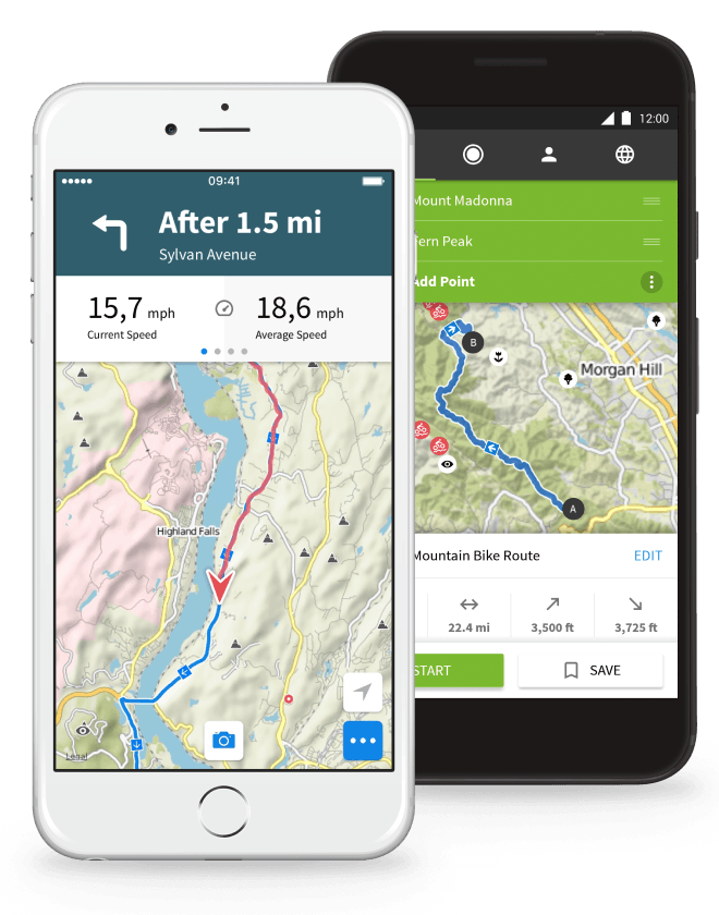
Route Navigation.
We did not find the route planning on Komoot as user friendly as cycle.travel. But once your route file (GPX) is up loaded to Komoot you can manage your navigation settings including Voice navigation, Auto Re-Route and for Android: Wake up screen.
When Navigating, about 50 meters before your turn the phone will either light up or make a sound. I have it set up to light up, the phone beeping every time you make a turn can be very annoying.
Visual turn-by-turn directions during komoot navigation
The arrows in the upper part of the screen are large and easy to read – really helpful. In the default settings, a large arrow clearly shows the direction of the next turn.
Directly below the turn-by-turn directions (arrows and distance), komoot shows you the following additional information:
- Speed: Current, Average, Maximum
- Distance: Distance traveled, distance remaining.
- Time: Time in motion, time remaining.
- Distance: Kilometers traveled
- Elevation meters: graphic altitude profile.
Swipe left or right to view the information.
As Navigation is what we use Komoot for I will not write about the planning part of the app, Komoot is a powerful tool and for us a useful back up to our main route planning app cycle.travel.
Points of Interest
I have used cycle.travel as my main route planning tool, as a quick way of finding local cycleways, voie vert and quiet routes, before uploading to Kamoot for navigation.
Pro's
- Excellent routing for outdoor sports
Komoot is geared towards those who do outdoor sports such as hiking or cycling by displaying common known trails as well as user created ones that are shared on the platform.
Con's
- No offline re-routing
Offline GPS will tell you when you have left your tour (and approximately what direction it is in), but cannot re-route without internet connection. Which can be inconvenient for those that deviate or get lost.
If you have found this useful please consider
buying me a coffee. A coffee helps turn the wheels!
You can find links to all our social media via Linktree
Copyright © 2024 Jenni and Martin Clarke. All Rights Reserved